Navigation menu
- Education
- Emissions & Air Quality
- Infrastructure & Services
- Meteorology & Climate
- News
- Physical Chemistry
- Projects
- The Team
Due to climate change, cities will increasingly have to deal with extreme heat events during the summer season. After 2003 and 2015, 2018 was another year with a summer that brought above-average temperatures in Switzerland during which excess mortality was observed (2003: 6.9%, 2015: 5.4%, 2018: 3.4%, source: BAFU, 2019). Therefore, it becomes increasingly important to adapt to these heat events in order protect people from the extreme heat. Since cities with their built-up nature heat up more potently than rural areas, climate adaptation strategies in cities are urgently needed, considering that city planning actions have a time horizon of decades.
The city of Zurich has identified the problem and released the “Fachplanung Hitzeminderung” in 2020, presenting strategies on how to approach the urban heat problem. The report presents a range of heat mitigation measures that can be applied in practice. One intriguing cooling mechanism are the katabatic cold air streams originating from the forested hills around Zurich. At night, these low-altitude atmospheric motions usually displace the heated air masses which develop over the course of a day. For these cold air streams to achieve maximum cooling effect in urban spaces, it is important that their paths are not obstructed by large obstacles. Therefore, optimizing the building placement (Handlungsansatz HA 02) can be quite an effective heat mitigation measure if there is cold air available to begin with. In the planning process of new buildings, it is interesting to see how a variant of a building changes the airflow downstream. This can be investigated with urban climate simulations.
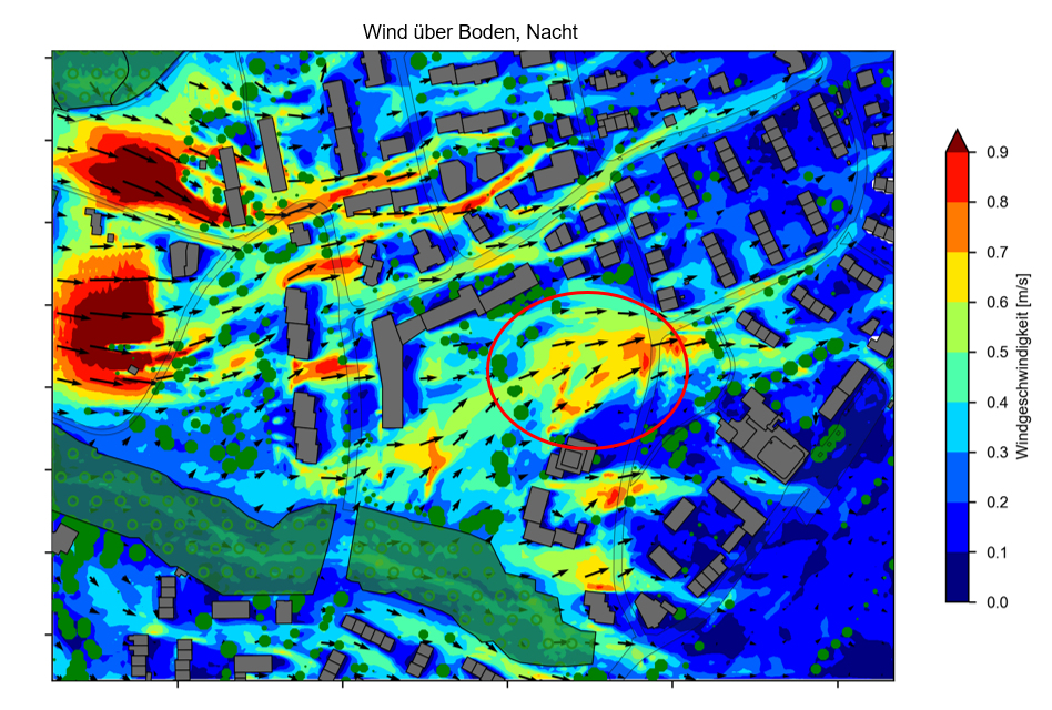
To start, it is relevant to know how much cold air mass movement an area sees without any blocking structure on it. An example of such a simulation can be seen below. The simulated terrain is sloping down towards the east. From the west, channeled cold air approaches the region of interest. One can already see that the cold air flow gets effectively blocked by the buildings upstream of the area where a new building is planned (red circle). Due to this, the air gets channeled along streets, which represent paths of least resistance to the air flow close to the ground.

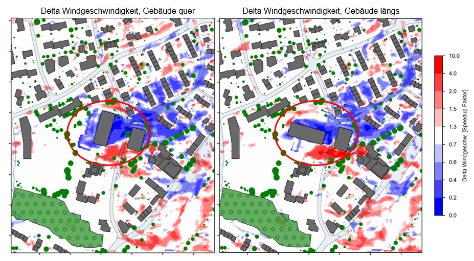
Then, multiple variants can be placed into the simulation and the difference in windspeed can be analyzed. In the example below, both variants create substantial wake, significantly reducing wind speeds behind the building, leading to less air exchange in the built-up areas just behind it. Blue areas represent a reduction of wind speed compared to the baseline (unobstructed area), red represents an increase in wind speeds.

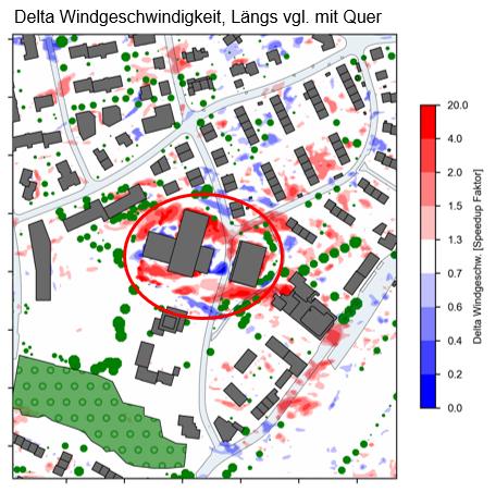
But which version is more favorable from a blockage perspective? Calculating the delta between the two building variants yields the result below. Red areas indicate a higher wind speed around the building “längs” (“along”, oriented west-east) in relation to the building oriented “quer” (“across”, oriented north-south).

With these results, one can decide which building orientation would be the least detrimental and add the most benefit from a local climate perspective. In tight architectural competitions, insights like this can be a good argument for or against a design.
So, does simulating cold air streams on a very local scale as seen above make sense? Yes, very much indeed if relevant cold air paths are close to the area of interest and significant windspeeds can be observed. If present cold air streams are almost negligible, other measures could provide much more interesting insights through simulation. For instance, simulating the effect of converting the area of a football field from asphalt to grass would be a better heat mitigation measure. Cold air flows are mainly a measure that displaces heat from an area. Preventing the generation of heat is even better.